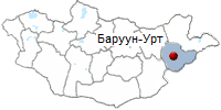
Sukhbaatar aimag. Region of Mongolia. Baruun Urt. Erdenemandal Khiid. Shiliin Bogd Uul.
ABOUT MONGOLIA
THE REGIONS OF MONGOLIA
SUKHBAATAR AIMAG.
- Territory - 31776 sq, miles (82,300 sq. km.)
- Center - Bamun-Urt town, located 346 miles
(557 km.) from Ulaanbaatar.
- Number of somons - 13
- Sukhbaatar aimag was established in 1943

Sukhbaatar aimag is situated in the eastern part
of Mongolia. The territory is hilly, predominantly steppe. The average altitude
is 3,281 - 3,937 feet (1,000 - 1,200 m) above sea level. The highest mountains
are Shiliin Bogda (5,830 feet /1.777 m) and Munkh Khan (5,249 feet /1.600 m).
Basalt covering of dead volcanos stretches as far as 3,861 square miles (10.000
sq. km) in the South - East of Sukhbaatar aimag.
In the province there are 220 dead volcanos, such as Shiliin Bogda, Zotolkhan,
Altan ovoo, Ayabadar, Asgat, Senjitiin Undur, Dosh, Ganga, Tsagaan ovoo and
Nart. 20 springs are found in the territory of the aimag, such as Dalai bulag,
Arnuur, Talbulag, Dashin and Ereen tolgoi. Lakes of Ganga nuur, Duut, Dosh are
popular destinations. North and north - western part of the territory has brown
soil, and the soil of the eastern part is pale, and brown. The southern part of
the territory is sand deserts, with Moltsog sand dunes stretching for miles (96
square miles /248 sq. km), Ongon sand (49 square miles /128 sq. km), and Suuj
sand. The South of the territory is semi-desert, and other parts of the
territory is mainly steppe. The aimag is rich in white antelopes. Running
animals resemble a yellow wave. The horn of male antelope was awarded gold
medal at the Turin International Hunting exhibition. Of other animals there are
foxes, corsas, wolves, marmots and wild cats.
PLACES TO VISITED.
- Baruun Urt. Population 17,000. Elevation 981m. Baruun Urt is a scruffy, dusty and sometimes rowdy town in the middle of absolutely nowhere. Most people live in large ugly apartment blocks and work in a new Chinese-invested zinc mine, or in another coal mine 7km to the north-west. The water in Baruun Urt has high levels of sulphur so you are better off buying bottled water or filtering the tap water. Some maps refer to the town as Sukhbaatar, which is confusing because this is the name of the capital of Selenge aimag.
If you are stuck in Baruun Urt, the museum in the dusty southern part of town is worth a look. It has a reasonable collection of costumes representing the three ethnic groups that inhabit the region: the majority Khaikh, Dariganga (30,000 live in the
South of Sukhbaatar aimag) and Uzemchin (about 2000 live in Dornod aimag and Sukhbaatar aimag). Look out for the interesting Uzemchin wrestling jacket.
There are also fine examples of products from Dariganga's renowned silversmiths and blacksmiths, some stuffed gazelle (which is probably about as close as you will ever get to one), a map showing the locations of the
'man' and 'woman' balbal statues in the aimag and some memorabilia of
Sukhbaatar.
Erdenemandal Khiid. According to the monks at the monastery, Erdenemandal Khiid was originally built in 1830, about 20km from the present site. At the height of its splendour, there were seven temples and 1000 monks in residence, but the Stalinist purges of 1938 had the same result as elsewhere.
- Dariganda. Dariganga sum in the south-east of Sukhbaatar is by far the most interesting place in the aimag to visit. Famous for its silversmiths and blacksmiths. Friendly Dariaanaa is also where the sand dunes of the Gobi and the grassy plains of the northern steppe converge to create what looks like thousands of hectares of perfect natural golf courses - but don't let any developer know!
To reach the sights in the area you will need a jeep and a good driver or guide. It's the only way to, firstly, get to Dariganga village (also known as Ovoot), and then to explore the lakes, volcanoes, mountains, sand dunes and ancient stones nearby. The sacred mountain
of Shiliin Bogd is also not too far away.
The skyline of Dariganga is dominated by Altan Ovoo (Golden Ovoo), a wide former crater topped by a new
stupa which only men are allowed to visit. The stupa was built in 1990 on top of the ruins of the original BatTsaagan stupa, which was built in 1820 and destroyed in 1937.
In the area around Altan Ovoo, there are dozens of broken balbal - their exact
origins are not clear. According to local tradition, you should place an offering of food in the cup held in the statue's left hand. There are also three balbals known as the king, the queen and the prince, in the north edge of town, near some hay sheds.
The ruins of Ovoon Khiid can be seen in the south-east edge of town. Built in 1820, it housed 600 monks before it was burned to the ground. The new Ovoon Monastery was built in 1990 and is served by six monks.
There are six lakes in the vicinity of Dariganga; all are part of the 28,000 hectare Ganga Nuur Natural Reserve. The three main lakes, Kholboo Nuur, Tsagaan Nuur and Ganga Nuur, are good for swimming, though a bit muddy.
The magnificent Ganga Nuur is about 13km south-east of Dariganga. Between the start of August and the end of October, the lake is home to thousands of migrating swans. Along the shore, in a fenced compound, is delicious and safe spring water.
The sand dunes in the region are known as Moltsog Els and stretch for 20km, coming to within walking distance of
Dariganga.
- Shiliin Bogd Uul. At 1778m, Shiliin Bogd Uul. about 70km East of Dariganga, is the highest peak in Sukhbaatar aimag. The extinct volcano is sacred to many Mongolians: the spirit of any man (and man only!) who climbs it, especially at sunrise, will be revived. The region is stunning, isolated and close to the Chinese border - so be careful.
Shiliin Bogd offers one of the greatest sunrises in a country full of great sunrises.
On the road between Dariganga and Shiliin Bogd, 8km past Ganga Nuur, look out for the new statue of Toroi-Bandi, the 'Robin Hood' of Mongolia, who had a habit of stealing the horses of the local Manchurian rulers, then eluding them by hiding near Shiliin Bogd Uul. The statue, dedicated in 1999, pointedly faces China.
Taliin Agui, 15km north-west of the mountain, is one of the largest caves in Mongolia. If the ice covering the entrance has melted (it's normally covered until August) you can squeeze through the narrow entrance. The large, and a little
claustrophobic cave has seven chambers to explore.
Khurguin Khundii is in a valley 40km West of Shiliin Bogd Uul, on the way back to Dariganga. Here a dozen or so ancient (pre-Chinggis Khaan) stone statues lay on the ground. The origins of these statues are debated: they are thought to either represent famous people from the region, or they were built to commemorate local women who jumped off a nearby mountain because they were forced to marry men they didn't love. You will have to rely on your driver to find the statues and to locate Bichigtiin Skhakhaa, a pretty canyon about 2km away.
- Lkhachinvandad uul Natural Reserve. If you are visiting Shiliin Bogd by jeep, you may wish to carry on
East for another 120km to the 58,500 hectare Lkhachinvandad Uul Natural Reserve, on the border with China. This reserve contains Lkhachinvandad Uul (1233m) and is full of gazelle and elk.
INFORMATION:
PAGES OF THE PICTURE ALBUM
|


 Classic tours