ABOUT MONGOLIA
THE REGIONS OF MONGOLIA
BULGAN AIMAG
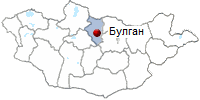
- Territory - 18,803 square miles (48,700 sq. km)
- Center - town, located 205 miles (330 km) from
Ulaanbaatar.
- Number of somons - 16.
- Bulgan aimag was established in 1938.
- Population - 67,300.

Bulgan aimag is situated in the North, in the territory of the Khangai mountain forest steppe zone. Bulgan aimag borders on the North with the Russian
Federation. Bulgan aimag is a curious mixture: the south is dry grassland and the north is green and has enough forest to support a small timber industry;
scattered in between are about 50,000 hectares of wheat and vegetable crops - Mongolia's agricultural heartland - and Erdenet, Mongolia's largest copper mine.
The ethnic groups comprise Khaikh, Buryat and Russians.
 Soil is sandy with semi-desert features in the South
of the aimag. A small mountain range, the Biirengiin Nuruu, bisects the aimag, and though it only reaches a maximum altitude of 2058m, it provides plenty
of lush habitat for wild animals and livestock. High mountains include: Bulgan Khan Uul, Buregkhangai, Dulaankhan. Soil is sandy with semi-desert features in the South
of the aimag. A small mountain range, the Biirengiin Nuruu, bisects the aimag, and though it only reaches a maximum altitude of 2058m, it provides plenty
of lush habitat for wild animals and livestock. High mountains include: Bulgan Khan Uul, Buregkhangai, Dulaankhan.
Mongolia's largest river, the Selenge Gol, crosses the aimag's north, and the Orkhon and Tuul rivers meander around the southern parts. Coniferous trees,
fruits and medical herbs such as berry, goosberry, hippobophae, plantago, great burhet, peony species of artemesia and thyme grow in the fertile soil. Mixed
forest occupies about 30 percent of the aimag's territory. Elks, bears, deer, white antelopes, boars, musk deer, lynxes, squirrels, marmots inhabit the area.
Bulgan aimag is rich in beautiful places, such as Eg-Selenge, Eg-Tarvagatai meadow,Uran-Togoo, Khugnukhan. Khuiji, Uurt and other springs of the province
are popular destinations. Of historic memorials there are remnants of old Stone Age, ruins, and the site of Baibalyk, the ancient city of Uighur State, and the
ruins of the residence of prince Tsogt. Bulgan is a famous area of pilgrimage of Mongolians due to its historic places. The main sector of economy is
agriculture. The aimag takes the 3rd place in the country for its farming. The local industry produces a broad range of products including foodstuffs, gold,
consumer and export goods. Average annual industrial output reaches 1.9 billion tugriks. Over 70 percent of aimag's budget comes from local revenues.
PLACES TO VISITED.
- Bulgan. Population 13,000. Elevation 1208m. A small aimag capital, the city of Bulgan has long been known to foreigners as an overnight stop midway between
Ulaanbaatar and the ever-popular Khovsgol Nuur. If you've been traveling in central or southern Mongolia, Bulgan city may impress you with its conifers,
log cabins and absence of gers, though there's little reason to linger.
The Aimag Museum on the main street has some information on obscure sights in the aimag, a display on J. Gurragcha, Mongolia's first man in
space, and some interesting old photos. The Museum of Ancient Things (Ugsaatny Zizuyn Salvar) has a few ethnographical exhibits.
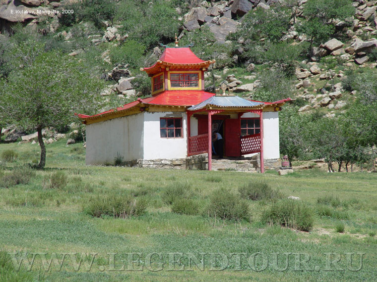
Dashchoinkhorlon Khiid. Like most monasteries in Mongolia, this one (built in 1992) replaces the original monastery, Bangiin Khiiree, which was
destroyed in 1937. About 1000 monks lived and worshipped at Bangiin Khiiree before they were arrested and, presumably, executed. The remains of several
stupas from the old monastery complex can be seen in the surroundings.
The modern monastery of Dashchoinkhorlon Khiid contains statues of Tsongkhapa and Sakyamuni and features a painting of the old monastery layout.
About 30 monks now reside there.
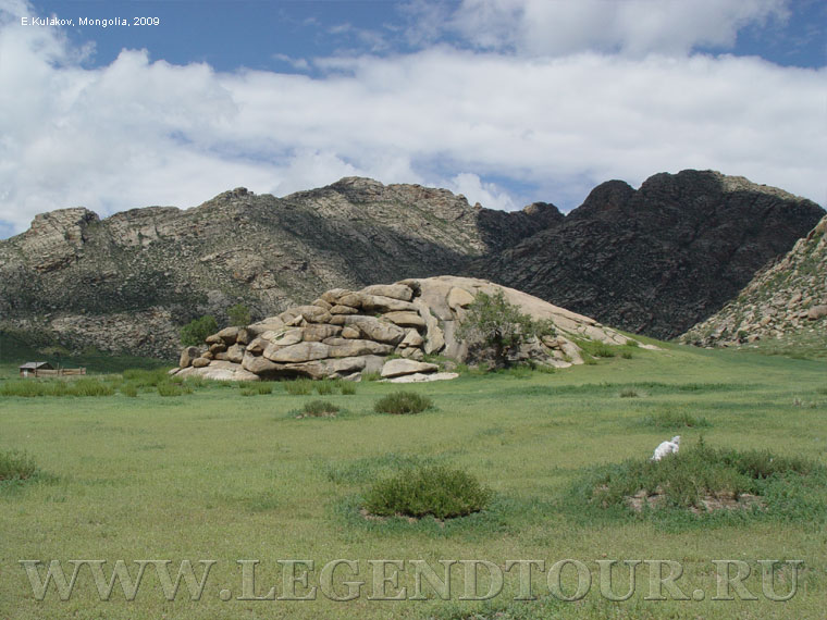
There are a couple of obscure historical monuments around Bulgan. About 20km South of Bulgan, just East of Orkhon are seven standing deer stones, so called
because the stones are carved with reindeers and other animals. The stones, known as Seeriyn Adigyn Bugan Khoshoo, mark what are thought to be Neolithic grave sites.
About 25km North of Bulgan is a Imtall Turkic balbal (Turkic grave markers), known as Zunn Turuuniy Khun Chuluu.
- Hogno Haan uul. Although it's just off the main Ulaanbaatar-Kharkhorin highway, this nature
reserve sees relatively few visitors. Its arid terrain of rocky semi-desert is good for short hikes and there are a few old temples to explore, both ruined and
active. At the southern foot of the mountain are the ruins of Ovgon Khiid, built in 1660 and destroyed (and the monks massacred) by the armies of Zungar Galdan Bochigtu, a
rival of Zanabazar's in 1640. About 10 monks reside here in the summer months. The head lama is a charming woman who professes soothsaying abilities.
- Ovgon-Khiyd Monastery. The monastery is located in the mountains of Khogno-Khan 257 km away from Ulan-Bator, on the way to
Arvaykheer, 173 km away from Arvaykheer and about 75 km away from Kharkhorin.
- Elsen tasarkhai is a part of the Mongol Els sand dunes, which
stretchs along the Tuv, Uvurkhangai and Bulgan provinces. The sand dunes are
totally 80 km long. Elsen Tasarkhai is located in Burd soum of Uvurkhangai
province and 280km from Ulaanbaatar on the way to Kharkhorin. It can be
translated as “sand fracture” and it continues 80 km long, 5 km wide in the
South of the Khogno Khan National Park.
- Uran Uul & Togoo Uul. About 60km directly west of Bulgan city is the extinct volcano of Uran Uul and nearby Togoo Uul, now part of the 1600
hectare Uran-Togoo Tulga Uul Natural Reserve in the sum (district) of Khutag-Ondor.
Uran Uul is a pretty good place to break the journey to Khovsgol, though the flies in this area can be intensely irritating.
Trails to the top of the relatively unimpressive volcano lead up from the west side, which also has some nice camping areas.
- Eg Tarvagatain Bilcher. This is a scenic area of rivers, forests and mountains, suitable for hiking and camping, though there are no
tourist camps as yet. It is in Teshig sum. Access roads are very poor in this region. Just East of Teshig is the pretty Khargal Nuur.
- Bugat. If you have rented a jeep with a driver, the best way to travel between Erdenet and Bulgan city is via Bugat village.
It is rough going, but the 40km jeep trail goes through some of the most picturesque forests and gorgeous wildflowers in northern
Mongolia (Bugat means 'Place of Elk').
- Erdenet. Population 74,000. In the autonomous municipality of Orkhon, and not technically part of Bulgan aimag,
Erdenet is Mongolia's third largest city. The reason for Erdenet's existence is the copper mine, which employs about 8000 people and is the lifeblood of
the city. Erdenet is modern (built in 1974) and a bit soulless, but far nicer than most towns in the countryside. It is comparatively wealthy, so the
facilities are the best outside of Ulaanbaatar. There is also a significantly large Russian community. Up to a third of the population of Erdenet was
Russian during Communist times, though now only about 1000 Russians still work as technical advisers at the mine.
- Dashinchilen. There are a couple of minor monuments in Dashinchilen sum, in the South of the aimag, which might be of interest if you are
travelling between Ulaanbaatar and Tsetserleg, via Ogii Nuur.
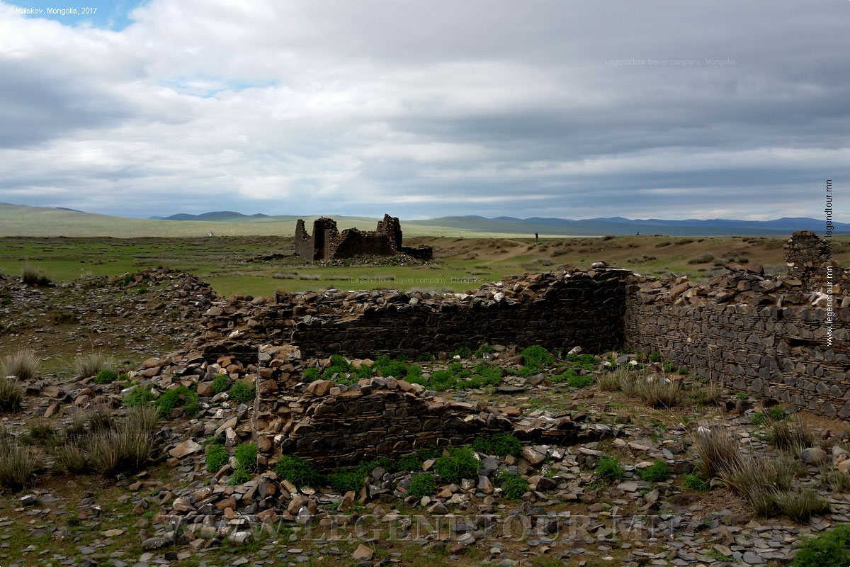
On the west side of the Tuul Gol, about 35km north-east of Dashinchilen, are the ruins of Tsogt (Tsogt Tayjiin Tsagaan Balgas), a 17th century fort
which was the home of the mother of Prince Tsogt, a 17th century poet who fought against Chinese rule. There is a stone stele nearby.
Closer to the sum capital, the ruined Khar Bukh Fortress (Khar Bakhin Balgas), might be worth exploring as it's just a few kilometers North of the main road.
- Uran-Togoo Tulga Uul Natural Monument.
Uran volcanoe (in Nothern part of image) and Tulga, Togoo, Jalavch volcanoes (in Southern part). Image is a SRTM DEM presentation with 30 m (100 feet)
resolutionThe Uran-Togoo Tulga Uul Natural Monument (Mongolian: Уран-Тогоо Тулга уулын дурсгалт газар) is a national protected area in the Bulgan Province of
Mongolia. It is located about 60km directly west of Bulgan city around the extinct volcanoes Uran Togoo, Tulga Togoo, and Jalavch Uul.
The area is situated in the Khutag-Öndör district of Bulgan Province. A smaller area was initially protected in 1965 by State Great Khural
Resolution No. 17. In 1995, it was designated as a monument by Parliament Resolution No. 26 with an area of 5,800 hectares.
- The ruins of an ancient city called Khar Bukh (Hadaasan) sit on the banks of the Khar Bukh river, northeast of
Khadaasan Tolgoi. Khar Bukhʼs ruins are located in modern Dashinchilen District,
Bulgan Province. This site dates back to two different periods of Mongolian
history, the first being the Khitan period of the 10th and 11th centuries. The
main reason for linking Khar Bukhʼs ruins to the Khitan period is that similar
inscribed roof tiles were found at another Khitan site at Qing Tolgoi. The
second period dates to the first half of the 17th century, when single-storey
stone buildings were built inside the walls of the ancient city. These buildings
consisted of a number of large temples with strong walls. The masonry
fortifications of these buildings are typical of this period, whilst their
design reflects a Tibetan style of construction.
- Prince Tsogt Taij White House ruin is
situated near Mount Khaldunzurkh in a valley of Tuul River 20km northeast from Chin Tolgoyn Kherem in Dashinchilen Soum, Bulgan
province. It was formerly a castle of Queen Madai Taigal, a mother of Prince Tsogt. This temple designed castle with a tiled roof was surrounded by several
small fortresses. The fortress had a gate in the south. There are many remains, perhaps, any settlement surrounding the castle. Therefore, it is said that many
people inhabited around the castle. This castle was designed alike buildings in ancient capital Karakorum and there was a big library which is rich with
Buddhist sutras and various kinds of books. In eastern hill of the castle, there was a turtle stone much same as that of Karakorum.
ADDITIONAL INFORMATION:
PAGES OF THE PICTURE ALBUM
|


 Classic tours