Dundgov (Middle Gobi). Mandalgobi. Middle Khalhasain Plain.
ABOUT MONGOLIA
THE REGIONS OF MONGOLIA
DUNDGOVI AIMAG
- Territory - 74,700 sq. km
- population of 51.300 inhabitants
- Center - Mandalgobi town, located 165 miles
(265 km) from Ulaanbaatar.
- Number of somons - 16
- Dundgovi aimag was established in 1942

Dundgobi Aimag is the middle segment of the
Gobi-desert. Dundgobi Aimag has an area of 74,700 square kilometers and
population of 51.300 inhabitants. The administrative center is the town of
Mandalgobi at an altitude of 1,393 meters sea level in the vast open steppe,
260 kilometers from Ulaanbaatar. The territory of the aimag is the central part
of the Middle Khalhasain Plain, with an average altitude of 1.500 meters above
sea level, and the highest point is Delgerkhangai Mountain, which reaches 1,926 meters above sea level.
The aimag is rich in coal resources. The mean annual temperature is 11°C. Average January and July temperatures are -18°C and 18,8°C. Annual mean precipitation is 163,8 millimeters.
Air pressure is 85OhPa in January and July. Annual wind velocity is 4,4 meters per second, and mean wind velocity is 5,8 meters per second in the month of May.
The aimag has one of the highest wind velocities in Mongolia.
There are many small lakes and springs. The Ongi River flows in the western part of the aimag. This territory is covered with steppe plants and has species of birds and animal
of rare varied. In the southern part it gradually turns into the desert zone of the arid Gobi. Total local livestock herd is 1.5 million heads.
The territory of Dundgovi aimag is semi-desert and steppe. The average
elevation of the area is 3248-6329 feet (990-1,926 m) above sea level and the
highest peak is Delgerkhangai peak in the Delgerkhangai somon. There is
semi-desert, such as Oldokh, Tugrug, Nomgon, Ergenegene, and many springs,
including Togoo, Ungut, Khadan Us. Aimag is pride of it's beautiful sceneries
such as Ikh Gazriin Chuluu, Baga Gazriin Chuluu, somon khukh oasis, Tsagaan
stupa-pyramid, and the Uush dunes. Elm, saksaul, tamarisk, almond are woody
plants, to be found anywhere in the territory of the province. Medical herbs,
such as artemesia, allium mongolicum, psammochloa, splenden, feather-grass,
wornwood, couch, wild-rose, liquirice, cynomorium, agriophyllium, annua,
cotoneaster grow nearly everywhere. Rare animals such as wild sheep, ibex,
antelope, black tailed antelope, marmot, fox, lynx, wild cat, badger and hare
may be occasionally encountered. Birds include eagle, kite, swan, pallous and
sandgrouse. Dundgovi aimag is rich in coal, copper ore, iron ore, fluorspar,
nephrite, jade, graphite, marble and chalcedony. The main branch of economy is
animal husbandry.
PLACES TO VISITED:
- Mandalgov. Population 11,000. Mandalgov came into existence in 1942, when the town consisted of just 40 gers. Today, it's a sleepy town that has had a major population
drop from 19,000 people 15 years ago. The town is very hot in summer. It offers the usual amenities for an aimag capital - an airport, a hotel, a monastery, a museum and a couple of shops. There is more to see around Sangiin Dalai, but Mandalgov is a useful stop-off on the way to Dalanzadgad in
Omnogov.
Aimag museum. It's open for everyone. The museum is divided into two main sections: a natural history section and a more interesting ethnography and history section. Among the displays is a bronze Buddha made by Zanabazar. There's also a
collection of priceless scroll paintings (thangka), old flintlock rifles, bronze arrow heads, silver snuffboxes, pipes, and chess sets carved out of ivory.
Dashgimpeliin Khiid. In 1936 there were 53 temples in Dundgov. A year later, they were reduced to ashes and rubble by the Mongolian KGB. In 1991 Dashgimpeliin Khiid was opened to serve the people of Mandalgov.
The monastery is small, consisting only of a monk's ger and a newly built temple, but it's very active inside. Visitors are welcome, but should show the usual respect.
Mandalin Khar Ovoo. On top of Mandalin Khar Ovoo, about 150m north-west of the park, is a viewing pavilion. It is worth the short climb for a panorama of all that Mandalgov has to offer (which isn't much).
Opencast coal mine. Tevsh Mine extracts brown coal and is 30 kilometers from Mandalgobi. The coal layer reaches 200 meters in the center.
- Baga Gazrin Chuluu. This is another granite rock formation in the middle of the dusty plains. In the 19th century, two revered monks lived here in gers - remnants of their rock drawings can be found in the area. The rocks are worshipped by locals who sometimes make pilgrimages here. Naturally, there is a legend that Chinggis Khaan stayed at the rocks.
Five kilometres away, the highest peak in the area, Baga Gazrin Uui (1768m), will take about five hours to climb. The mountain also contains a cave with an underground lake. The mineral water springs and trees in the region make it a great spot to camp, and there are plenty of rocky hills, topped by ovoo (sacred pyramid-shaped collections of stone and wood), to explore.
Picturesque mountain Baga Gazar Chuluu is a picturesque mountain at an elevation of 1,751 meters in the Granite Belt. Its valleys abound with streams. A resort for children is here.
Süm Khökh Burd. The ruined 10th-century temple Süm Khökh Burd sits on an
island in the middle of a seasonal lake, and was built from rocks that can only
be found more than 300km away. It was abandoned and left in ruins a few
centuries later and 300 years ago a palace was built in its place. When that too
fell into disrepair, the writer Danzan Ravjaa built a stage here. Makes sense.
The setting is that dramatic.
Behind it, enough of the temple and palace remain to give you some idea of their
previous magnificence. Even in ruins, with needle grass sprouting between the
stones, it's an impressive sight, thanks largely to its remote location. In the
evening when guests are on the premises, the ruins are lit up magnificently.
However, it's largely the domain of luxury tour groups and Buddhist scholars,
and outside of July the grounds may be locked (we hopped the fence, which is
easily done). During peak season, you may be lucky enough to stumble upon a
naadam performance staged on the concrete amphitheatre which fronts the ruins.
The lake itself, Sangiin Dalai Nuur, only encircles the palace after heavy
rains, but the perennial marsh provides good bird-watching. Various species of
eagle, goose and swan come to this spring-fed lake in summer and autumn.
The temple is located 72km northeast of Erdenedalai, 65km northwest of Mandalgov
and 21km west of Baga Gazryn Chuluu.
Delgeriin Choir. This monastery is located on the north south of mountain of Baga Gazriin chuluu.
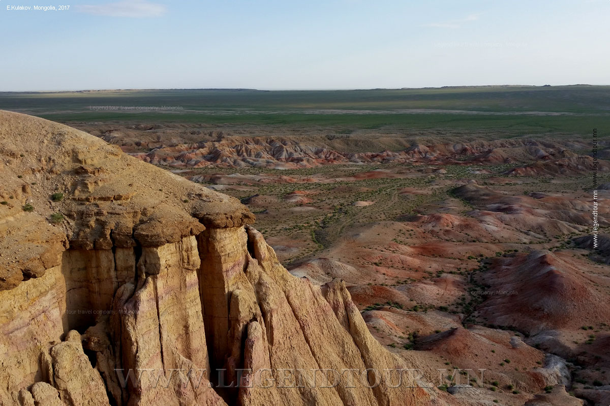
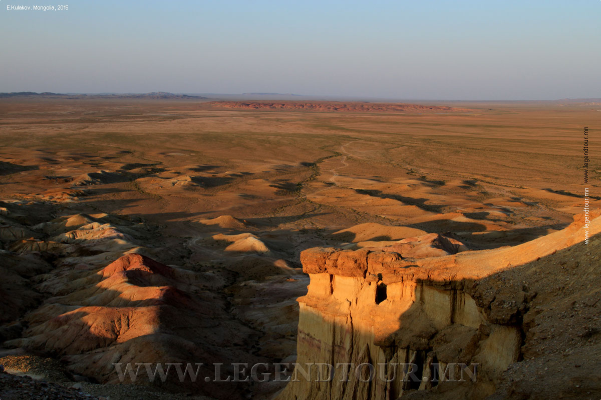
- Tsagaan Suvarga. 420 km from Ulaanbaatar, 85 km from Ulziit town in
Dundgobi province, and 30 km east of the Ulaanbaatar-Umnugobi main road. 30-60 m
high, 400 m long, colorful limestone formation, once was the ocean bed where the
visitors find marine fossils and clamshells. Its colors are outstanding early
morning and evening. Tsagaan Suvarga was named after its shape resembles the
Buddhist relict stupas or pagodas. Tsagaan Suvarga is a beautiful photo shooting
spot both day and night. There are some trails to hike down and up through the
cliffs. Except for the cliffs, 50m-long Khevtee Bosoo Cave is worth a visit.
People have abundant time may spend a day exploring ancient rock drawing gallery
in mountains located 32 km from Tsagaan Suvarga. Several ger camps and
family-run ger guest gers accommodate travelers. Alternatively, you may break
your journey for a short on your way between Dalanzadgad and Mandalgobi cities.
- Chuluu and north south of Ikh Delger Mountain. It was palace of Zavadamdin where he wrote his books. Now the monastery is working.
- Shireet Tsagaan Nuur Shireet Tsagaan Nuur is 30 kilometers north of
Burd soum on the southern foot of the Mongol Mountain in Mongol Els.
The Shireet Tsagaan Nuur is the place where Zanabazar, the Mongolian
enlightened of the 17th century, was promoted to being head of Mongolian
Buddhism and set up the foundation of Khutag Palace, the future Ulaanbaatar,
in 1639. The palace foundation were laid at Shireet Tsagaan Nuur in 1639, a
location only 30 kilometers to the north of the present geographical center of
the country, and the Zuun Khairhan Mountain was formerly called the
geographical center of Mongolia.
- Sangiin Dalai Nuur. Although little more than a large pond, you can see some remarkable birdlife at Sangiin Dalai Nuur. Mongolian larks and various species of eagles, geese and swans come to this spring-fed lake in summer and autumn.
The temple Khukh Burd Sum, which sits on an island in the middle of the tiny lake, was built in the 10th century. Remarkably, the temple was built from rocks that can only be found over 300km away. It was abandoned and in ruins a few centuries after being built.
Three hundred years ago, a palace was built here, and 150 years later, the writer Danzanravjaa (see the Sainshand section later in this chapter) built a stage on top of the ruins. Enough of the temple and palace remain to give you some idea of what a magnificent place it once must have been.
- Erdenedalai. This sometime camel-herding community in the middle of nowhere, 114km northwest of Mandalgov, is a good base for visiting nearby attractions if you have your own vehicle. It's also a useful halfway stop between Arvaikheer (in Ovorkhangai aimag) and Mandalgov, or an alternative stop to Mandalgov between Ulaanbaator and
Dalanzadgad.
- Ongiin Khiid. It is a ruin of big monastery of Bari Yonzon Khamba on the banks of the Ongiin River. East part of this monastery has many buildings on the south slope of the Rocky Mountain like Balsa country and some stupas haven't broken. This monastery had about thousand lamas. Also there are some tourist camp such as Tsagaan ovoo &
Munkhkhaan. This monastery, with its temple Damba Darjalan Sum, is a very pleasant surprise after travelling around the dusty and dull countryside. Built in the late 18th century to commemorate the first ever visit to Mongolia by a Dalai Lama, the monastery was once used by about 500 monks. It was the only monastery out of nine in the immediate vicinity to survive the Stalinist purges - by becoming a warehouse and
shop. The monastery was reopened in 1990 and the current Dalai Lama visited in 1992. The small contingent of 20 monks visits three or four times a month.
- Tsogt Taij Chuluu. About 75km South of Sangiin Dalai village, there are some inscriptions on rocks written by Mongolian scholars and
nationalists, including the last known descendant of Chinggis Khaan, Tsogt Taij (1561-1637).
Written in 1621, in an ancient Mongolian script, which is hard for locals to
understand, the inscriptions are mildly interesting (if a little too well preserved to believe), but hardly warrant a special visit.
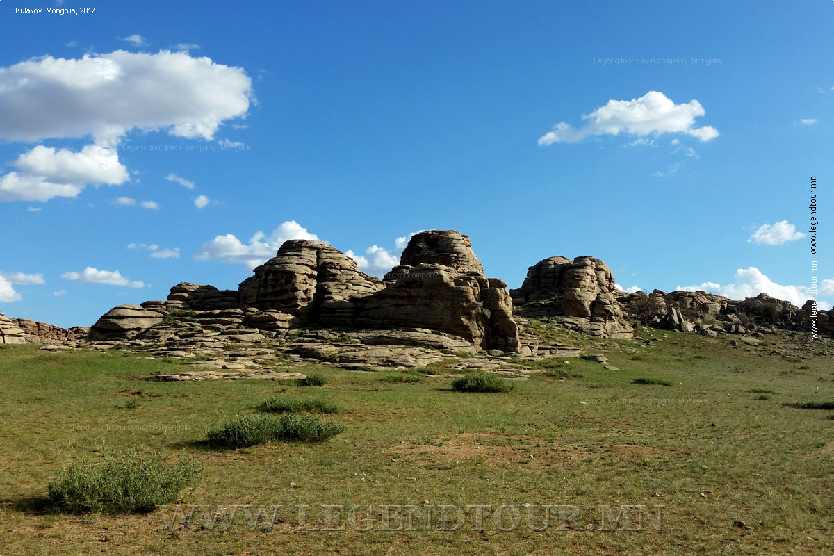
- Ikh Gazrin Chuluu. This area of unusual rock pinnacles is about 70km north-east of Mandalgov in Gurvansaikhan sum.
- Ulaan Suvraga. In the most southern sum of Olziit is Ulaan Suvraga, an area that might be described as a 'badlands' or a 'painted desert'. The eerie, eroded landscape was at one time beneath the sea and is rich in marine
fossils and clamshells. There are also numerous ancient rock paintings in the region.
The museum in Mandalgov has a photograph of Ulaan Suvraga, which you might want to look at to decide if it's worth the effort of getting here.
- Inscribed rock of Duut. Of special interest is an inscribed rock of Prince Tsogt Taij, located on the territory of Delgerkhan soum in Tuv Aimag. A well-known poet of the 17th Century, Prince Tsogt Taij carved his 30-line poem on the rock in 1626. This rock gained the name "Duut" because it tinkles like a steel boiler as one hits it. The inscription has been preserved as though written only yesterday.
- Khariin Nuu. Khariin Nuur is in the valley of the Bor to the north of Adaatsag Mountain. Here is a place Guseer Nuur mentioned in the 'Secret History of Mongols'.
- Zorgol Khairkhan Uul. Zorgol Khairkhan Uul is in Bayanunjuul soum in Tuv Aimag. The mountain is composed of granite rock, being in the Granite Belt of Mongolia.
The mountain has an elevation of 1.686 meters above sea level, and was mentioned as Zorgol Khan in the 'Secret History of Mongols'.
- Mountain of Ongon Khairkhan. The mountain lies on the territory of Buren soum, in the Granite Belt of Mongolia. In 1968 on the mountain a mineral new to Science was discovered, later given the scientific name of
"ongolite".
- Large sand dunes Uush Mankhan is an interesting place with big sand dunes, lying in the northern part of the center of Buyant Bag. A picturesque place, Zagiin Us, is 50 kilometers southeast of Uush Mankhan. A spring, Tugaliin Buleen, is in Khuld soum and famous for curative properties.
- Del mountain. It is a small schist range in Ulziit and lies to the northwest and southeast about 25 km. It has many hills in sequence and every hill is far 10 km -s from others. So it is named Del Uul.
- Cliffs sculptured by wind The scarp of Tsagaan Suvraga is in Ulziit soum. It is interesting to see the sheer slope, facing east; from a distance it seems to be the ruins of the ancient city. The cliff is 30 meters high and 100 meters wide. Over thousands of years the wind has created this amazing structure.
"Ulaan Suvraga", which has a similar structure, is on the territory of Ulziit soum at Sair Us. Ulaan Suvraga also has numerous ancient rock paintings, and the eroded landscape is rich in fossil seashells.
- Mountain of Delgerkhangai Uul. Delgerkhangai Uul is in Delgerkhangai soum in a vast plain, and the mountain reaches 1.926 meters above sea level. It is rich in rare animals and many streams and gorges are in the valley.
- The spring of Bari Khamba. It is an unfrozen space which takes it's source from underground and locates on the corner of a building on the East Side of the monastery of Ongi. It has composition of chloridium, bi-corbonate, natrium and magnesium and used for treating internal diseases.
- Erdenedalai soum. This soum is the largest herd of livestock in Mongolia (326,000) and the monastery of Ugtaal Sangiin dalai has been operated its activities still now which has enjoyed state protection since 1998. There is a tourist camp named Dundgobi.
ADDITIONAL INFORMATION:
PAGES OF THE PICTURE ALBUM
|


 Classic tours