Mongolia. Geographical zone. Information for travelers.
TRIP TO MONGOLIA TOURS
INFORMATION FOR TRAVELERS
GEOGRAPHICAL FEATURES

Mongolia is one of the few countries, which possesses a great range of natural ecosystems within their borders. Mongolia is located at the junction of Siberian taiga and Central Asian prairie
steppe and deserts, and therefore specific species of fauna and flora are included in the territory. Largely unknown to the rest of the world until recent years, Mongolia's unique combination of
diverse landscapes, unspoiled habitat, and rare wild plant and animal species clear water and fresh air has started to attract international nature conservation organizations and has become the
subject of growing international attention. Mongolia is divided into six basic natural zones, differing in climate, landscape, soil, flora and fauna.
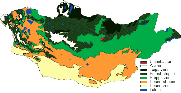
HIGH MOUNTAIN ZONE
Mongolia is a mountainous country. Though the high mountain zone, which includes the higher elevations of these ranges, makes up only about 5 percent territory of Mongolia, average
elevation of the country is quite high, at 5,184 feet (1,580 m.) above sea level. In the Far Western Altai, Khuiten Peak in the top parts of Tavan Bogda Mountains reaches 14,350 feet (4,374 m.), the
highest point in the country. Altai, Khangai and Khentii mountain ranges and the Khuvsgul Mountains are higher than the height of forest zone. Many mountain areas of Mongolia show signs of previous
Ice Ages, with U-shaped valleys and boulders left behind by retreating glaciers. The climate in the high mountain zone is extremely cold, and there is a short growing season. Located above tree line,
the zone is characterized by tundra, alpine-sedge meadows, highland swamps, and lichen-covered boulder fields.
Highest Mountainous of Mongolia
| Nairamdal peak (Tavan Bogda Mountain) |
14,350 feet (4,374 m.) |
| Sukhbaatar peak (Munkhkhairkhan Mountain |
13,806 feet (4,208 m.) |
| Tsast Mountain (Altai mountain range) |
13,793 feet (4,204 m.) |
| Tsast Bogda Mountain (Sutai mountain range) |
13,417 feet (4,090 m.) |
| Khatuu Mountain (Siilkhem mountain range) |
13,217 feet (4,029 m.) |
| Khukh serkh (Deluun mountain range) |
13,186 feet (4,019 m.) |
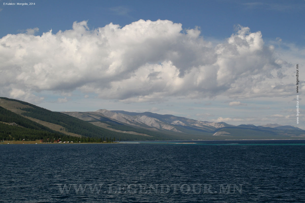
TAIGA (FOREST) ZONE
Taiga zone which covers 5 percent of Mongolian territory occurs only in northern Mongolia, where it is found in the Khentii Mountains, in the mountainous terrain around Lake
Khuvsgul, back part of Tarvagatai mountain range, first higher place near Orkhon river and some parts of Khan Khukhii mountain range. The taiga zone experiences more precipitation (12 to 16 inches
annually) and lower temperatures than most of Mongolia, therefore plant growing period is comparatively short. Stepping considerably affects the edge of Taiga zone and steppe elements penetrated to
sides and along wide trenches of shorter mountains.
FOREST STEPPE ZONE
The forest steppe zone covers about 25 percent of the territory, and is one of the most heavily populated areas in Mongolia. The forest steppe zone occurs in the northern frontier
of Central Asian prairie steppe and desert and southern frontier of Eastern Siberian forests
Khentii, Khangai branch mountainous, the Mongolian Altai Mountains occurs in the eastern frontier, in the
Orkhon and Selenge river basins, and in the Khyangan mountains. This zone is the real example of steppe and forests coexist in mountainous area and affect each other. Watershed of the world occurs in
the zone and besides this, haphazard usage from the forests is dangerous for convicting the zone into mountainous steppe zone. Its pastures, wood, and water make it an important area for herders
and their livestock.
STEPPE ZONE
Steppe covers nearly the entire far-eastern part of Mongolia, extending west in a narrowing band just south of the Khangai and Khan Khukhii Mountains all the way to the Depression
of the Great Lakes. Mongolia's steppe lies in the eastern part of the vast plain that begins in Eastern Europe and reaches to the steppes of Manchuria. The steppe zone includes a distinctive group of
flora and fauna. In the central and western areas of the country, the steppe provides many of the nation's most important grazing lands for domestic livestock. The steppe is vulnerable to impacts from
overgrazing, agriculture, roads and other human activities.
DESERT STEPPE ZONE
Desert steppe occupies a large band, more than 20 percent of Mongolia's area, extending across the country between the steppe and desert zones. This zone includes the Depression of
the Great Lakes, the Valley of the lakes, and most of the area between the Khangai and Altai mountain ranges, as well as the eastern Gobi area. The zone includes many low-lying areas, soils with salt
pans, and small ponds. The climate is arid with frequent droughts and annual precipitation of 4-5 inches (100-125 mm.), and frequent strong winds and dust storms strongly influence the area
vegetation. Still, many nomadic herders of Mongolia occupy this zone.
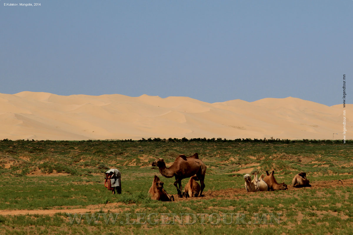
DESERT ZONE
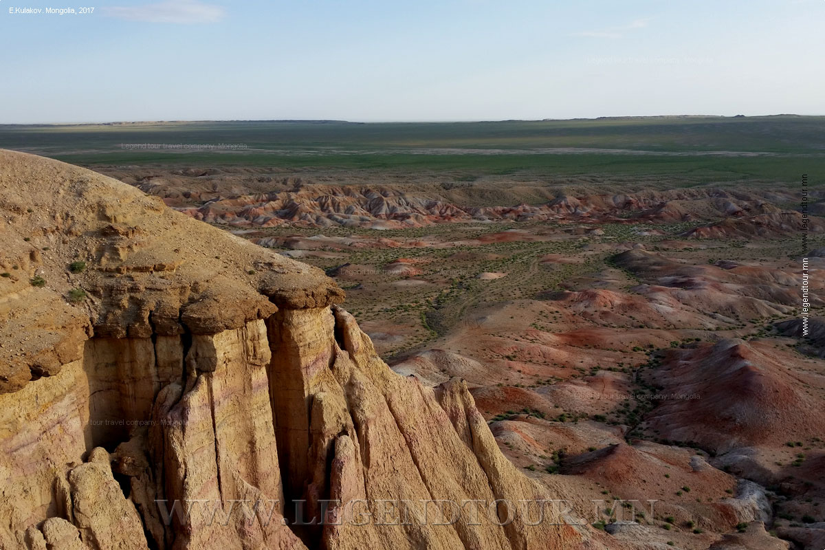
The Gobi is one of the great deserts in the world, occupying much of southern Mongolia and northeastern China and composing the northern part of Central Asian deserts. Starkly
beautiful, the expanses of the fabled Gobi are rugged and inhospitable. Vegetation is sparse here, and the zone displays a remarkable variety, from rocky mountain massifs to the flat pavement-like
areas of the super-arid desert, from poplar-fringed oases to vast out wash plains and areas of sand dunes. These areas provide habitat for many threatened species of Mongolia, including the wild
camel, Gobi bear, and wild ass. Climate is extreme. Precipitation may fall only once every two to three years and averages less than 4 inches (100 mm.) annually. Temperatures climb as high as 104° F
(40° С) in summer, and fall as low as 104° F (-40° С) in winter. During the spring and fall, dangerously strong winds buffet the area with dust storms and wind-speeds up to 140 km/ hour.
FEATURES OF MONGOLIAN GEOGRAPHY
- Mongolia's surface area is 1 566 500 square km. It is the 17th largest
country in the world. This represents 1.05% land of the world.
- Mongolia is situated in the centre of Asia, or in the center of eastern
part of the world.
- The country's northern border point lies at 52.09* north latitude
(Mongol Sharyn Davaa), the southern point at 41.35* north latitude (Orvog
Hoshuuny Tolgoi), the western point at 87.44* east longitude (Maanit Mount
of Altai Tavan Bogd Mountain), and the eastern point at 119.56* east
longitude (Modot
Khamar in Hyangany Mountain).
- The distance is 1259 km from north to south, 2392 km from west to east,
the total frontier is 8158 km.
- The highest point is the peak of Altai Tavan Bogd Khuiten Uul, attains
an altitude of 4374 meters above sea level, and the
lowest point, Khukh Nuur Depression (Blue Lake), is 552 meters above sea
level.
- The geographical center of the country lies 13.5 km away from Burd Soum
of Uverkhangai Aimag at 46.52* north latitude and 103.50* east longitude at
the source of Uverkhusheet Spring.
- The aimag center of the highest elevation is Altai town of Gobi-Altai
Aimag. It is located at an altitude of 2160 meters above sea level, almost
equal to the height of Bogd Khan Mountain towering on
the south of Ulaanbaatar. As for soum centers, it is Duut Soum of Hovd
Aimag, placed at an altitude of 2400 meters above sea level.
- The aimag center of the lowest elevation is Sukhbaatar town of Sukbaatar
Aimag located at an altitude of 626 meters above sea level. As for soum
centers, it is Ereentsav Soum of Dornod Aimag, located at an altitude is 600
meters above sea level.
- There are three major mountain ranges. The Altai
Mountain Range (Altayn Nuruu) sweeps from the
northwestern tip of the country, thrusting toward the southeast, the Khangai
Mountain Range looms up in the central part and the Hentyi Mountain Range
lies in the north-eastern part, with over 10 snow-capped peaks towering at
more than 4000 meters above sea level.
EARTHQUAKE
Mongolia is in the seismic zone. The most frequent earthquakes occur in
Gobi-Altai Aimag. In average, there are 70 to 140 moderate earthquakes per
year. The inhabitants are aware of 2 to 4 occurrences only. A chronicle of
earthquakes in Mongolia:
- Chinggis Khaan's hand-writers left a note about a severe earthquake
struck Mongolia in the XIII century. The note says: "Red hot molten
stones were erupted from the mountain, hot liquid stones like fire were
overflowing, and wild fire smoke covered the surroundings".
- The earthquake occurred in 1570 near Egyin Davaa was of 10-11
magnitude on the Richter Scale.
- In July 9, 1905 a very severe earthquake occurred in Khan Khuhyi
Mountain and Bulnai Mountain Range, leaving a long surface rupture.
- The Gobi-Altai earthquake of December 4, 1957, known as the Ikh Bogd
earthquake in Mongolia stands out as one of the great intracontinental
earthquakes. As a result a vast area underwent major deformation, and
there were considerable human and animal losses.
- During the 1967 Mogod earthquake of 7-8 magnitude on the Richter
Scale, strike-slip faulting occurred along a 36-km-long, north trending
zone and terminated at its southern end in a 13-km-long
southeast-trending thrust rupture.
- An earthquake occurred in Deren Soum of Dundgobi Aimag in September
1998.
EXTINCT VOLCANO
There are about 400 extinct volcanoes in Mongolia. Many of them are
found in Dariganga Soum of Sukhbaatar Aimag. There are 220 volcanoes.
The most beautiful extinct volcano is Uran Uul found in Bulgan Aimag.
The latest extinct volcano is Horgo in Arkhangai Aimag. The highest
volcano is Jaran Bogd Uul elevated to 2607 meters above sea level, which
is between large and small Bogd Mountains.
Cave: More than 1000 caves have been registered in the country. Of
it, about 200 caves are regarded as large. The largest cave is Talyin
Agui, 14 kilometers northwest of the mountain Shilyin Bogd Uul in
Dariganga Soum of Sukhbaatar Aimag.
- Dayan Derkhyin Agui: The cave is in Tsagaan Uur Soum of Huvsgul
Aimag. It has more than 10 compartments.
- Tsagaan Agui: This cave is in Bayanlig Soum of Bayankhongor
Aimag. The back side of cave's opening is of blue rocks and the
front side of its opening is of yellowish rocks. Scholars have
established that human beings lived in this cave 730 000 years
before our era.
- Tsenkeryn Agui: The cave is 25 kilometers away from the center
Mankhan Soum of Hovd Aimag. It is 15 meters high. Famous petroglyphs
drawn 4000-3000 years before our era are found on its walls. These
are paintings of ostrich, mountain goats, buffalo and birds.
UNIQUE PLACES OF GEOGRAPHICAL INTEREST
- The highest atmospheric pressure center in the Northern
Hemisphere arises in Mongolia during winter. The area covering
Uvs Nuur and Khyargas Nuur (Lake) Depression is called the Asian
Centre of the highest atmospheric pressure in the geographical
science. The atmosphere pressure reaches 1,055hPa in January in
Ulaangom, centre of Uvs Aimag. No such a regular atmospheric
pressure centre comes to notice in the world.
- The world northernmost desert is in Mongolia: It is a dune (Buuregyin
Els) found in Zuungobi Soum of Uvs Aimag. The dune's northern
verge reaches 50.18* north latitude. This is almost parallel
with the southern part of Canada, or the south coast of Gudzon
Bay in the Arctic Ocean.
- The southern verge of permafrost in the Northern Hemisphere
is in Erdenetsogt Soum of Bayan-Hongor Aimag, at 46.17* north
latitude near Daragt Mountain, which lies in parallel with the
northern coast of Mediterranian Sea.
- The distance between Buuregyin Els and the southern verge of
permafrost is only 700 kilometers. There is no other place in
the world where desert pushes forward far north and permafrost
pushes forward far south.
- The peak of Tsogt Chandmana Mountain at the end of the
Khentyi Mountain Range is found about 80 kilometers south of
Ulaanbaatar at an altitude of 1845 meters. It is the watershed
of three huge drainage basins: the Arctic Ocian, Pacific Ocean
and the Inland Basin of Central Asia.
- The longest earthquake fault line can be traced for 350
kilometers from near Lake Sangyin Dalai in Huvsgul Aimag west to
the source of Khangiltsag River in the Khan Khukhii Mountain
Range. The open fissures were 60 meters deep and 10 meters wide
in some areas.
- The two important lines of latitude and longitude pass
through Mongolia: This is the 45th parallel and the 90th
meridian lying between the Equator and the North Pole.
BIBLIOGRAPHY:
- Facts about Mongolia 2000. by Da. Gandbold. ADMOND Co.Ltd., Mongolia.
PAGES OF THE PICTURE ALBUM
|


 Classic tours